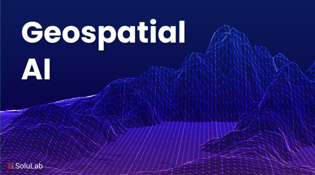

The use of geospatial AI is transforming our understanding of and interactions with the world. With its intelligence, it transforms analytics by providing unmatched insights into geographical data. This technology provides dynamic solutions for a range of industries by combining artificial intelligence and geospatial data.
This revolution’s key component is the use of AI in geospatial analytics, which makes complex analysis and decision-making possible. The opportunity for predictive modeling, real-time analysis, and geographical detection on an unprecedented scale is made possible by the integration of AI technologies with geospatial data. The geospatial analytics market is expanding significantly in the midst of this innovation.
As to a recent analysis by Grand View Research, the market was estimated to be worth $85.77 billion in 2022 and is anticipated to grow at a compound annual growth rate (CAGR) of 12.6% from 2023 to 2030, when it is expected to reach $226.53 billion. The quick expansion demonstrates how highly businesses regard geospatial AI, which is applied to anything from environmental protection to city planning.
The need for advanced geospatial AI solutions is rising as more businesses try to use geospatial data to make more informed decisions. This pattern suggests that in the future, geospatial AI will be crucial to human comprehension and administration of the environment.
In this blog, we will go into great detail about how geospatial AI is revolutionizing analytics and not simply being an invention. But let’s first make sense of what GeoAI is all about!
What is Geospatial AI?
A subfield of artificial intelligence known as “geospatial artificial intelligence” (GeoAI) uses geographic data and the analytical capabilities of AI to produce insights and solutions for a variety of businesses. Companies can make predictions, optimize operations, and comprehend patterns like never before by utilizing the ability of geospatial AI to analyze geographical data in more complex ways.
Technology has the potential to completely transform the fields of logistics, environmental monitoring, and urban planning while opening the door to more accurate decision-making. By incorporating GeoAI into the business plan, you may significantly improve your use of geographical data and make more educated and wise decisions. Through the use of GeoAI, businesses may successfully negotiate the complexities of today’s data-centric market and position themselves for success in a very competitive digital ecosystem. In order to fully embrace technological innovations and maximize the use of geospatial data in corporate processes, this adoption is a critical step forward.
What is Geospatial Intelligence?
Geospatial intelligence (GEOINT) refers to the collection, analysis, and interpretation of data about the Earth’s surface, atmosphere, and features. It involves integrating various types of spatially referenced information, such as satellite imagery, aerial photography, maps, GPS data, and other geographic information systems (GIS) data, to understand and interpret patterns, relationships, and trends.
GEOINT is used across various domains, including military and defense, environmental monitoring, urban planning, disaster management, agriculture, natural resource management, and more. It helps decision-makers gain insights into various aspects of the Earth, such as terrain analysis, infrastructure assessment, monitoring of human activity, and identification of potential threats or opportunities.
Benefits of Geographical Intelligence for Enterprises
The analysis and interpretation of geographical data are changing as a result of geospatial AI. This technology allows accurate decision-making and predictive analysis across numerous sectors by providing creative solutions for a range of difficulties. Below, we’ll take a closer look at a few of the main advantages of geographic artificial intelligence.
1. Improved Decision Making
Accurate data analysis increases the efficiency of decision-making. Spatial data insights allow organizations to make more accurate predictions about the future. For sectors like as logistics and urban planning, this accuracy is essential. This technique is greatly enhanced by the application of AI in geospatial analytics. It enables speedy processing of complicated data sets.
Businesses are now able to make well-informed judgments more quickly than in the past. Maintaining an advantage in highly competitive marketplaces requires this skill. It also promotes sustainable development by allocating resources as efficiently as possible. This technology has a significant influence on strategic planning since it converts data into actionable insight.
Related: Hybrid AI- A Complete Guide
2. Enhanced Effectiveness and Financial Savings
Efficiency is crucial in the fast-paced world of today. By streamlining processes, geospatial AI cuts down on time spent on data processing. Large geographic datasets are processed automatically using this technique. Moreover, it guarantees quicker insight delivery, which is essential for making decisions in real-time. Companies use this to streamline their routes, cutting down on fuel expenses and speeding up deliveries.
The operational costs of geographical data processing are greatly reduced by using AI. Businesses gain from improved resource management and lower labor expenses. By putting these savings toward expansion and innovation, a competitive advantage may be strengthened. One of the main forces behind cost savings and operational effectiveness is geospatial AI.
3. Superior Predictive Skills
Among the primary advantages of geospatial AI is its advanced forecasting capabilities. This technique uses geographical data processing to provide remarkably accurate future scenario forecasts. Proactive decision-making is facilitated by its ability to help companies foresee changes and trends.
The predictive capacity of AI geospatial data applies to a wide range of fields, including urban planning and environmental protection. It helps in guaranteeing the best possible use of available resources. It anticipates possible dangers and possibilities by looking for patterns and correlations in spatial data.
Better strategy planning, risk management, and investment choices are made possible by this foresight. In the end, geospatial AI’s sophisticated predictive powers enable stakeholders to more skillfully handle upcoming obstacles. Consequently, they will be able to secure a competitive edge and promote sustainable growth.
4. Better Equity and Accessibility in Services
The equity and accessibility of services are greatly improved across several industries via geospatial AI. By precisely identifying the locations where services are most required, this technology guarantees more equitable and effective resource allocation. AI in geospatial analysis directly addresses gaps within communities by assisting in the equitable distribution of healthcare, education, and other essential services through the analysis of enormous volumes of geographical data.
Geospatial generative AI encourages the creation of policies that seek to provide everyone access to necessities, therefore fostering inclusion. Geographical artificial intelligence (AI) is essential to creating a more just society since it maximizes the provision of services to marginalized communities. It guarantees that each person has access to the resources they require.
5. Analyzing Data in Real Time
AI in geospatial real-time data analysis greatly improves decision-making and operational efficiency. When time is of importance, our cutting-edge technology immediately processes and interprets geographical data to provide vital insights. Because of its ability to analyze data instantly, firms are able to adapt to changing situations better. Geospatial artificial intelligence’s precision and speed allow for more efficient resource allocation, which lowers expenses and waste.
Additionally, it enables companies to quickly adjust to changes in the market and keep a competitive edge. Additionally, real-time insights support more intelligent, well-informed strategy planning in a variety of businesses. proving the significant advantages of incorporating geospatial AI into regular operations.
6. Higher Public Safety and Security
Higher public safety and security are pivotal advantages of geospatial mapping technology. This innovation facilitates more efficient monitoring and mitigation of risks across both urban and rural landscapes. Through the analysis of geographic data, geospatial mapping identifies potential hazards, spanning from natural disasters to human-induced threats. It enhances emergency response strategies by forecasting where resources will be most necessary. The capability to visually represent intricate data geographically assists law enforcement agencies in both preventing and investigating crimes.
Moreover, geospatial mapping bolsters infrastructure resilience, aiding in the protection of critical utilities and services against disruptions. These developments make significant contributions to community well-being, ensuring a safer environment for all.
Use Cases of Geospatial Analytics
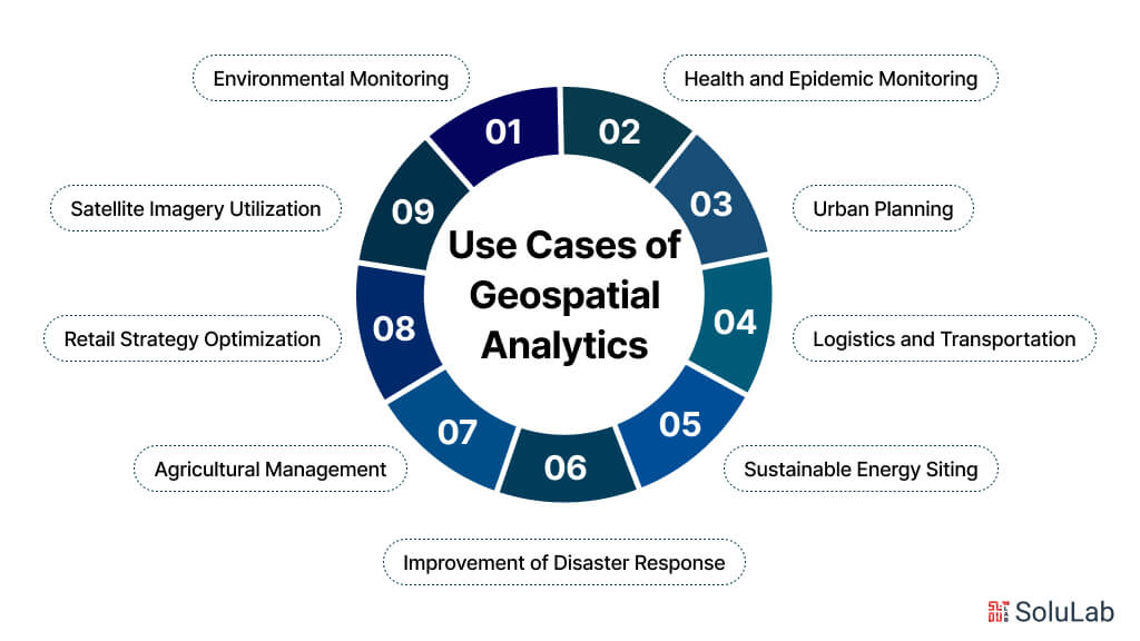
AI for geospatial applications in analytics is transforming our understanding of and interactions with the environment. Its uses are numerous, ranging from environmental monitoring to urban planning. Below, we’ll take a closer look at a few of the geospatial analytics use cases.
1. Environmental Monitoring
The use of geospatial artificial intelligence in environmental monitoring helps to monitor and protect the ecosystems on our planet. It correctly maps changes in urbanization, aquatic bodies, and vegetation. This method finds unlawful land use, tracks the consequences of climate change, and detects pollutants. Geospatial AI swiftly identifies regions of environmental risk by studying satellite photos. It makes it possible to take prompt action to lessen negative impacts on natural environments.
Strategies for conservation gain a great deal, guaranteeing focused conservation efforts. In addition to monitoring air quality, this technology helps combat pollution. It also evaluates the likelihood of disasters, enhancing emergency readiness. Geospatial artificial intelligence (AI) enables accurate data analysis to assist conservation and sustainable management strategies, preserving the health of the environment for coming generations.
2. Urban Planning
AI in geospatial analytics has enormous potential benefits for urban planning. This geospatial modeling technology can help in the construction of smarter cities by analyzing complicated data. Because of its ability to forecast population expansion, infrastructure development, and resource allocation can be done effectively. AI can determine the best places to put public services, making them more accessible. By using predictive modeling, it may also lessen traffic congestion and enhance traffic flow.
It can facilitate environmentally conscious urban growth by incorporating planning procedures. It can also aid in the revival of urban areas by pointing out unused areas that could be developed. AI has the potential to improve urban settings by fostering resilience, livability, and efficiency by offering thorough insights into urban dynamics.
3. Health and Epidemic Monitoring
Utilizing AI geospatial services, tracking health and epidemics emerges as a pivotal application. This technology adeptly maps disease spread in real-time, pinpointing hotspots and trends. It harnesses diverse data sources like travel patterns and climate conditions to forecast future outbreaks.
In public health, AI geospatial services customize intervention strategies, optimizing resource distribution for maximal impact. This tailored approach improves vaccination campaigns by directing efforts to areas of greatest need.
Moreover, it evaluates the efficacy of public health measures, adapting strategies based on emerging data. Offering a nuanced understanding of geographic disease transmission, AI geospatial systems enable more precise and efficient responses to public health emergencies, ultimately preserving lives and resources.
4. Logistics and Transportation
AI in geographic analysis has a lot to offer the transportation and logistics industries. Time is saved by route planning optimization. Smarter rerouting is further enabled by traffic estimates. As a result, there are much fewer delays and more accurate delivery dates.
Using predictive geospatial intelligence solutions driven by AI has the potential to revolutionize the logistics and transportation sector. It can improve the effectiveness of the supply chain by locating bottlenecks and quickly resolving them. Additionally, fleet management may see significant advancements because of effective maintenance schedule planning and ongoing vehicle health monitoring.
The industry as a whole is seeing improvements in efficiency and sustainability, which in turn is driving down prices. Geospatial analytics reshapes logistics with smarter solutions, opening the door to more dependable and environmentally friendly transportation options and driving the sector toward creative and efficient solutions.
5. Sustainable Energy Siting
Because geospatial data analysis can precisely measure solar and wind power, it can optimize the site of renewable energy sources. This technique determines the best sites for solar farms and wind farms. Appropriate site selection minimizes environmental consequences. It makes land use compatibility analysis possible. Planning for infrastructure becomes more effective and efficient. Timelines for project development might be shortened.
It is possible to maximize energy output in line with sustainability objectives. Selected sites can be strategically lowered in cost. Overall, the project’s efficiency and viability increased. This strategy encourages the switch to renewable energy. It helps to sustainably satisfy the world’s energy needs.
6. Agricultural Management
AI has the ability to foresee and prevent pest outbreaks before they cause serious harm. This has the potential to greatly improve sustainable farming methods and raise agricultural production.
Environmental impact may be reduced by using AI-powered geospatial analysis to assist strategic planning. It is possible to enhance soil fertility through crop rotation techniques, which will result in better crops. Applying fertilizer wisely helps cut down on waste and pollution to the environment. Data-driven insights can help save water resources more successfully.
7. Improvement of Disaster Response
Essential guidance for effective search and rescue operations is provided by geospatial analytics. Geospatial analytics also makes it easier to identify safe evacuation routes and effective methods for delivering relief.
Precise evaluations of damage derived from geospatial data accelerate the process of recovery, hastening the reconstruction phase and being essential to the prompt reinstatement of foreign assistance.
8. Retail Strategy Optimization
Retailers can now make more informed decisions about every part of their business with the help of GeoAI. Retail companies can gain knowledge that helps them make strategic decisions.
With the use of advanced technology, it is possible to identify the best sites for new stores by examining customer demographics and identifying trends in their behavior. GeoAI enables merchants to comprehend market patterns more deeply.
Beyond the confines of a business, geospatial analytics may optimize supply chain management by determining the most effective routes, which eventually lowers delivery times and costs.
9. Satellite Imagery Utilization
The fields of remote sensing and satellite images are being revolutionized by the combination of artificial intelligence and geospatial analytics. This potent combination makes it possible to detect even the slightest changes in flora and land usage, which improves environmental monitoring. Additionally, it makes weather forecasting more accurate, which eventually strengthens our capacity to prevent and respond to calamities.
Examples of Geospatial Technology
Geospatial technology, encompassing tools and techniques that capture, analyze, and visualize geographic data, has become indispensable across various industries. Here are some geospatial technology examples in action:
1. Global Positioning System (GPS): GPS is perhaps the most widely known geospatial technology. It utilizes a network of satellites to provide location and time information anywhere on Earth. GPS has applications ranging from navigation in vehicles to tracking wildlife movements.
2. Geographic Information Systems (GIS): GIS integrates hardware, software, and data for capturing, managing, analyzing, and displaying all forms of geographically referenced information. It’s used in urban planning, natural resource management, emergency response, and countless other fields to make informed decisions based on spatial data analysis.
3. Remote Sensing: Remote sensing involves gathering information about the Earth’s surface from a distance, typically using satellites or aircraft. This technology is used in agriculture to monitor crop health, in environmental science to track changes in land use, and in disaster management to assess the extent of damage caused by natural calamities.
4. LiDAR (Light Detection and Ranging): LiDAR uses laser pulses to measure distances to the Earth’s surface, creating detailed 3D maps. It’s employed in forestry to estimate tree heights and biomass, in archaeology to discover hidden features of landscapes, and in urban planning for precise elevation measurements.
5. Location-Based Services (LBS): LBS utilize the geographic location of a mobile device to provide personalized services or information to users. Examples include navigation apps, location-based advertising, and geotagging in social media.
6. Geospatial Analytics: Geospatial analytics involves analyzing spatial or spatiotemporal data to uncover patterns, trends, and relationships. It’s used in retail for site selection, in healthcare for disease mapping, and in transportation for optimizing routes and logistics.
7. Geographic Data Mining: Geographic data mining applies data mining techniques to spatial data sets. It’s used to identify spatial patterns, such as hotspots of crime or areas prone to natural disasters, aiding in predictive modeling and risk assessment.
8. Digital Elevation Models (DEMs): DEMs represent the elevation of the Earth’s surface as a grid of square cells. They’re used in various applications such as flood modeling, terrain analysis for infrastructure planning, and simulating line-of-sight visibility.
9. Geospatial Simulations: Geospatial simulations model real-world processes in a spatial context. They’re used in urban planning to simulate traffic flow, in ecology to model species distribution, and in military operations for scenario planning.
10. Drone Technology: Drones equipped with cameras and other sensors capture high-resolution aerial imagery and data for mapping, surveying, and monitoring purposes. They’re used in agriculture for precision farming, in construction for site monitoring, and in search and rescue operations for assessing disaster zones.
Prospects For Geospatial AI in the Future
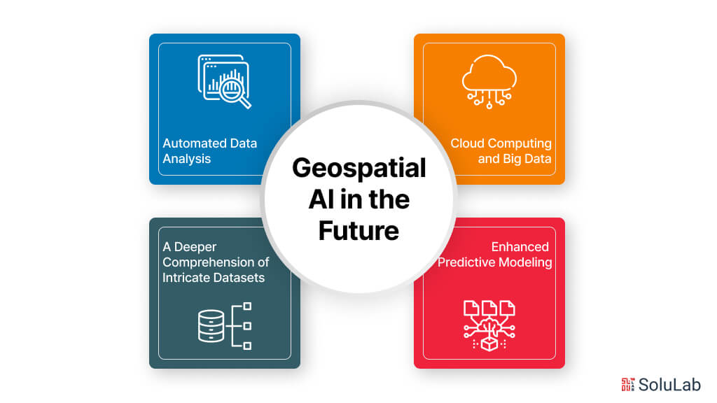
GeoAI has the power to completely change how we gather information and arrive at conclusions. The following are some expected developments that this merger should bring about:
1. Cloud Computing and Big Data
With the on-demand, scalable resources that cloud platforms offer, users may take on sophisticated calculations without being constrained by conventional infrastructure. Artificial intelligence (AI)-powered big data analytics can reveal latent patterns and trends in geographical data.
2. A Deeper Comprehension of Intricate Datasets
We will be able to glean more insightful information from intricate geographical data sets thanks to geospatial AI. This will make it possible for us to spot correlations and patterns that would be challenging to spot using more conventional techniques.
3. Enhanced Predictive Modeling
More precise models that forecast future occurrences may be created with Geospatial modeling. Numerous uses for this can include anticipating traffic patterns, estimating crop yields, and determining the likelihood of natural disasters.
4. Automated Data Analysis
Numerous data analysis activities, including feature extraction and data cleansing, may be automated using geospatial data analysis. Human analysts will be able to concentrate on more difficult jobs as a result.
Challenges To Take Into Account With Geospatial AI
Although GeoAI holds great potential, there are several drawbacks. The two main issues are security and privacy of data. Given the quantity and variety of geographic data available, maintaining data quality may be difficult and have a significant impact on the accuracy of AI forecasts. Here are some difficulties to think about:
1. Volume and Complexity of Data: The amount of geospatial data, which includes GPS coordinates and satellite photos, is growing rapidly. This abundance creates a hurdle since large datasets require complex algorithms and a lot of computing power to process and analyze effectively.
2. Bias and Quality of Data: Geographical data might differ widely in terms of consistency and quality. Data may be incomplete or contain mistakes. There might be a bias in satellite imaging toward specific weather conditions. For geospatial AI models to produce accurate and trustworthy results, they must be resilient enough to manage these flaws and reduce the impact of biases.
3. Privacy Issues:Sensitive information about individuals and locations is frequently found in geospatial data, and as geospatial AI applications advance in sophistication, privacy issues also increase. It is crucial to strike a balance between safeguarding people’s privacy and utilizing the value of geospatial data. It will be essential to create strong data governance frameworks and anonymization methods in order to responsibly build geospatial AI.
4. Ethical Considerations: Many ethical concerns are raised by the application of geospatial AI. In addition to the potential for privacy issues, algorithmic bias may provide discriminatory results when using geographical data to follow and monitor specific persons. In order to ensure the responsible use of this potent technology, ethical frameworks for geospatial AI development and implementation must be developed.
5. Standardization and Interoperability: There are several formats and standards for geospatial data. This lack of consistency might make it more difficult for data to integrate and flow between various platforms and apps. Encouraging interoperability and standardizing geographic data formats are essential to enable the smooth integration of geospatial data in AI systems.
6. Accessibility and Skills Gap: Specialized expertise and abilities, ranging from data science to geographic information systems (GIS), are needed for geospatial AI. For many organizations and people who may profit from this technology, a barrier may be created by the high cost of geospatial data and the lack of accessibility to these abilities. Developing user-friendly tools and bridging the skills gap will be essential to democratizing access to geospatial AI. 
Conclusion
Businesses may now make data-driven decisions thanks to the potent mix of artificial intelligence and geographic data that geospatial AI delivers. This technology provides real-time insights and optimizes processes.
However, handling and integrating complicated geographic data calls for knowledge. You may close this gap by collaborating with an AI development company. They can help your company navigate an increasingly complicated environment by converting your geographic data into useful insight. At SoluLab, we’re all about making your business smarter and more efficient. We are a well-known AI development companythat specializes in creating custom solutions using the latest AI technology. Whether you need help with things like predicting trends, automating tasks, or just making better decisions, we’ve got you covered. Let’s work together to take your business to the next level with AI.
FAQs
Shipra Garg is a tech-focused content strategist and copywriter specializing in Web3, blockchain, and artificial intelligence. She has worked with startups and enterprise teams to craft high-conversion content that bridges deep tech with business impact. Her work translates complex innovations into clear, credible, and engaging narratives that drive growth and build trust in emerging tech markets.